


Table of Contents Show
A site plan example shows a whole property from above: boundaries, existing and proposed structures, access, parking, and utilities. A plot plan shows the same lot but usually stops at property lines, setbacks, and building footprints. In most US permit offices the two names describe one required document, so the wording on your local checklist decides what you submit.
That overlap is where the money gets lost. Homeowners order a stamped boundary survey when a scaled drawing would have passed review, and small firms submit a design-quality sheet when the reviewer only wanted three dimensions from the lot lines. Both mistakes come from treating the terms as fixed technical categories. They are not.
What Is a Site Plan?
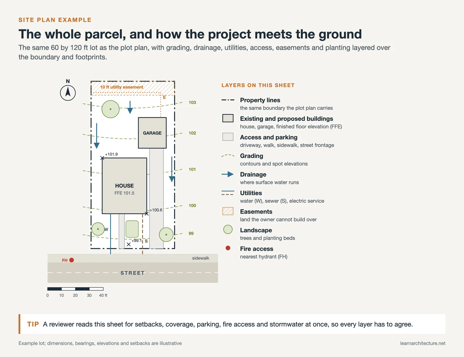
A site plan is a scaled drawing of an entire parcel viewed from above, showing how a project meets the ground. It carries property boundaries, existing conditions, proposed construction, circulation, grading, drainage, utilities, and landscape. Architects, civil engineers, and landscape architects all contribute to one, and it usually sits at the front of a drawing set at scales between 1 inch = 10 feet and 1 inch = 50 feet, depending on parcel size.
The purpose is proof. A reviewer opens the sheet to confirm that the design respects setbacks, lot coverage, height planes, parking counts, fire access, and stormwater rules. Our breakdown of the architectural site plan and its elements covers the full anatomy of that sheet, including how the base drawing gets assembled from survey and GIS data for site planning.
Larger projects push the site plan into a formal review track of its own. Fairfax County, Virginia, for example, runs site plan submissions through stormwater, erosion control, and wetlands checklists before a building permit is even discussed. That level of scrutiny is what people usually mean by site plan in a commercial context.
What Is a Plot Plan?
A plot plan is a drawing of a single lot, anchored to its legal boundaries, showing where structures sit relative to those lines. The word plot is the giveaway: the drawing is about the parcel, not the design. A typical plot plan drawing carries the property lines with dimensions, a north arrow, the outline of every building with distances to each lot line, driveways and walkways, and the zoning setback lines the structures have to clear.
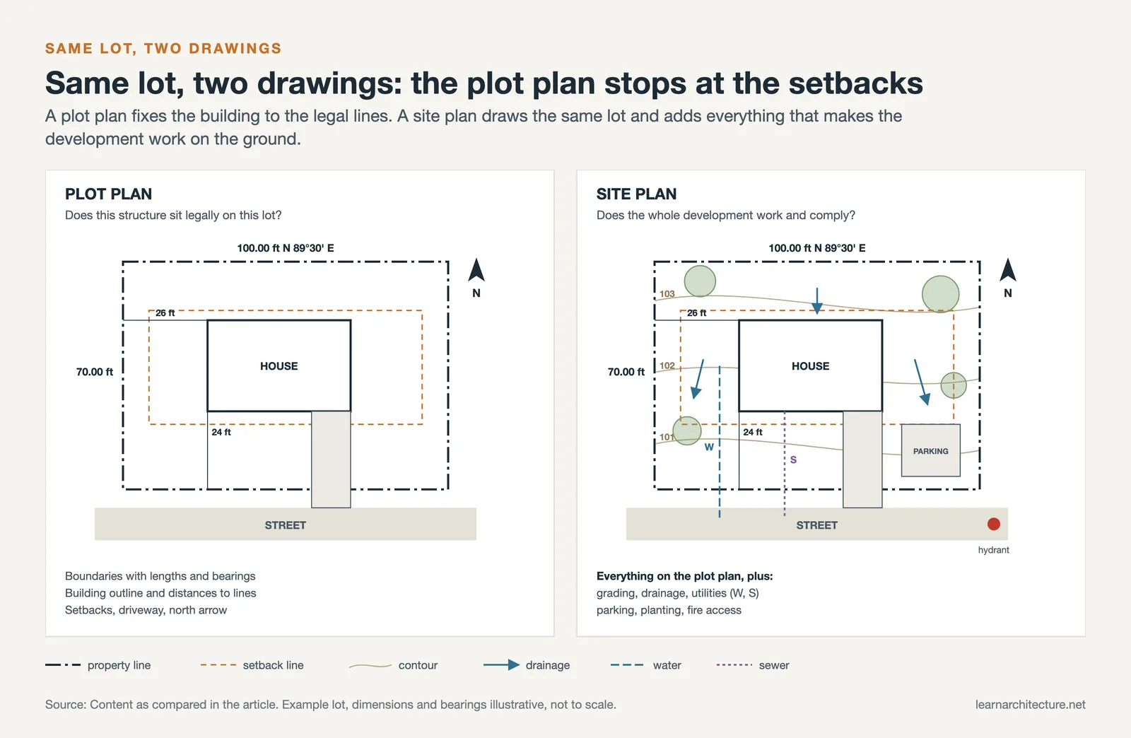
What it leaves out matters as much. Contours, utility inverts, planting schedules, and lighting layouts are usually absent, because nobody reviewing a shed or a rear addition needs them. That makes a plot plan example fast to produce and easy to read, which is exactly why residential counters ask for one.
The term also carries a second, stricter meaning in some jurisdictions. Boston’s building permit checklist calls for a certified plot plan drawn by a registered land surveyor for certain work, which is a different product at a different price from a drafted plan. When a checklist uses the word certified, it has stopped talking about a drawing and started talking about a survey.
Site Plan vs Plot Plan at a Glance
The table below sets out where the two terms genuinely diverge in practice, setting aside jurisdictions that use them interchangeably.
| Feature | Site Plan | Plot Plan |
|---|---|---|
| Scope | Whole property plus adjoining context | One lot and what stands on it |
| Typical content | Grading, drainage, utilities, parking, planting, fire access | Boundaries, setbacks, building outlines, driveway, north arrow |
| Who prepares it | Architect, civil engineer, or landscape architect | Drafter, designer, surveyor, or the owner where allowed |
| Question it answers | Does the whole development work and comply? | Does this structure sit legally on this lot? |
| Typical project | Commercial, multi-building, or subdivision work | Additions, garages, decks, sheds, pools, fences |
| Legal weight | Approval document, boundaries taken from a survey | Same, unless labelled certified, which requires a surveyor |
Why the Building Code Does Not Separate Them
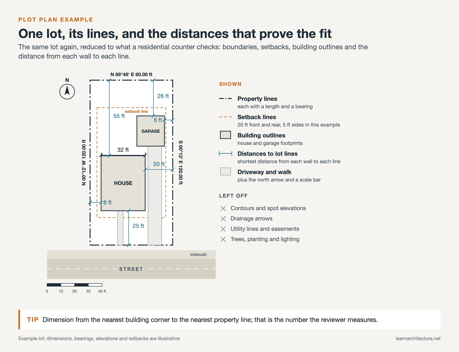
Here is the part most comparisons skip. The model code that governs American house construction does not draw the distinction at all. Section R106.2 of the 2024 International Residential Code requires permit applications to be accompanied by a site plan showing the size and location of new and existing construction and the distances from lot lines, then refers in the same paragraph to what remains on the site or plot. Many jurisdictions print that provision on their checklists under the heading “Site Plan or Plot Plan,” treating the two words as one requirement.
City guidance follows the same logic. Portland’s permit guidance defines the site plan as the drawing showing the whole property and the footprint of all structures, then adds that it is often called a plot plan. So the practical rule is not to learn a definition. It is to read the exact words on the checklist your reviewer works from, and to ask what level of accuracy sits behind them.
🔢 Quick Numbers
- 1 inch = 10 feet is the minimum scale accepted for site plans in Portland, Oregon, and the plan must show the entire lot (City of Portland Permitting and Development, permit application guidance)
- 1:200 or 1:500 are the scales the UK Planning Portal names for a site plan, also called a block plan, in a planning application
- 1:1250 or 1:2500 are the scales the Planning Portal specifies for the separate location plan that identifies the site in its surroundings
Do You Need a Survey, or Just a Drawing?
This is the question the terminology hides, and the one that actually changes your budget. A drafted plan plots boundaries from county records, parcel data, and measurements taken on site. A survey has a licensed professional certify where those boundaries physically are. Both can be titled “plot plan” on the cover sheet, and both can be labelled as a site plan example in a permit packet, so the title tells you nothing about the accuracy behind the lines.
Guidance from Michigan State University Extension puts the sequence plainly for smaller projects: identify which unit of government handles planning and zoning where the property sits, collect property dimensions and the local setback standards, and ask the office directly what form of plan it accepts, including whether a hand drawn plan is acceptable. That one phone call resolves more permit uncertainty than any amount of reading about definitions.
The threshold worth watching is proximity. When a structure lands within a foot or two of a setback line, when corner markers are missing, or when a neighbour disputes a boundary, certified measurements settle a question that a drafted plan can only estimate. Zoning limits shape that judgement too, which is why early feasibility work on setbacks and lot coverage pays off before any drawing starts.
⚖️ Pros & Cons at a Glance
✔️ Ordering a certified survey: boundaries are legally defensible, disputes with neighbours have an answer, the same data serves every future project on the property, lenders and title companies accept it.
✖️ Ordering a certified survey: costs several times a drafted plan, needs scheduling and site access, adds weeks to a permit timeline, and is more precision than a fence or shed application usually calls for.
How to Read a Site Plan Without Missing Anything
Reading a site plan example is a checklist habit rather than a talent. Five passes cover almost everything a reviewer looks for.
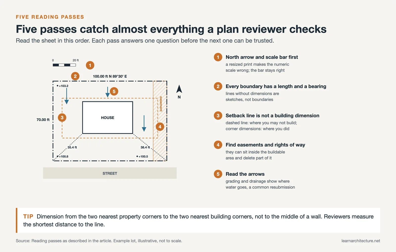
- Find the north arrow and the graphic scale bar first. Printed drawings get resized, and a numeric scale that no longer matches the paper is the fastest way to misread every dimension on the sheet.
- Trace the property lines and check that each one carries a length and a bearing. Lines without dimensions are sketches, not boundaries.
- Separate setback lines from building dimensions. The dashed setback shows where you may not build, while the dimensions from the lot line to the nearest building corner show where you actually did.
- Look for easements and rights of way. Utility and access easements can sit inside a buildable area and quietly delete a chunk of it.
- Read the arrows. Grading arrows, spot elevations, and drainage direction tell you where water goes, and stormwater is a common cause of resubmission.
One habit saves repeat corrections: dimension from the two nearest property corners to the two nearest building corners rather than dimensioning to the middle of a wall. Reviewers measure the shortest distance to the line, so give them that number directly instead of leaving it to be calculated. If any of the graphic conventions on the sheet are unfamiliar, our guide to architectural symbols covers the line weights and notation used here.
Site Plan vs Floor Plan: A Different Question
The site plan vs floor plan pairing confuses fewer people, though it is worth stating cleanly. A floor plan is a horizontal slice through a building showing rooms, walls, doors, and windows. A site plan stops at the roofline and describes everything outside it. One tells a reviewer how the interior works, the other tells them whether the building belongs where it stands. If you need the interior sheet as well, our step by step guide to drawing a floor plan handles that side.
What These Drawings Are Called Outside the US

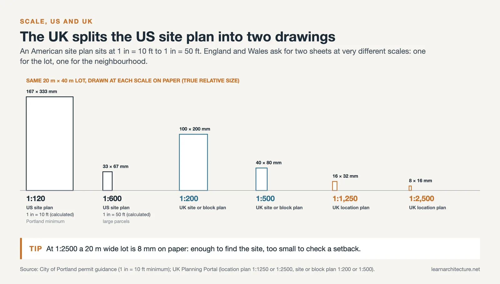
Plot plan is largely an American term. In England and Wales, a planning application asks for two separate drawings, and the Planning Portal defines both. The location plan shows the proposal in its surroundings at 1:1250 or 1:2500, with the application site outlined in red and any other land the applicant owns nearby outlined in blue. The site plan, also called a block plan, sits at 1:200 or 1:500 and shows the existing and proposed building against the property boundary along with adjacent street widths.
So a British applicant searching for a plot plan is really looking for a block plan, and an American applicant reading UK guidance will find their single required drawing split in two. Translating between the two systems is a matter of matching scale and purpose, not vocabulary.
Building codes, zoning rules, and submission requirements vary by jurisdiction. Confirm drawing requirements with the authority that will review your application before preparing or commissioning any plan.
Looking Ahead
The naming argument may be quietly dissolving. As counties publish parcel geometry as open GIS data and permit offices move to digital submission, the drawing stops being the record and becomes a presentation of a record that already exists in a database. What a reviewer really wants to know is whose boundary data sits underneath your linework, and how confident they can be in it. Once that question is answered, the label on the title block hardly matters.











Leave a comment